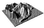
| 3D-Model 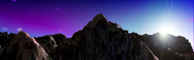
A
"virtual copy" of the mountain has been created
by Teknikhuset in cooperation with ProTECH AB. At this
page you can read about how the 3D-model or "virtual
copy" was made and you can also find computer
rendered 3D images based on the model.

 Plaster
model Plaster
model During the preparation of the Hidden
Peak Expedition, an architect created a model of
the mountain. This model is made out of plaster
and its size is apx. 70*70 centimeters. The model
was created with help from contour lines that
exists on different maps of the mountain. The
contour lines were cut out of the map, then a
pasteboard copy of the contour lines was created.
When all the contour lines were cut out, they
were glued together and finally covered with
plaster. During the preparation of the Hidden
Peak Expedition, an architect created a model of
the mountain. This model is made out of plaster
and its size is apx. 70*70 centimeters. The model
was created with help from contour lines that
exists on different maps of the mountain. The
contour lines were cut out of the map, then a
pasteboard copy of the contour lines was created.
When all the contour lines were cut out, they
were glued together and finally covered with
plaster.
The model has been
used during the preparation of the expedition,
for presentations and exhibitions.
|
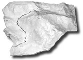
Plaster model
|
3D-digitalization
When the plaster
model was finished, ProTECH AB digitized the model using
a 3D-scanner. The scanner read all 3 dimensions of the
model and generated an array of 3D-coordinates. From the
array ProTECH created 3D-splines that represent the
surface of the mountain.
ProTECH
AB
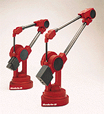
Microscribe
3D-Scanner
|
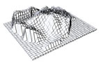
Wireframe model of
the Gasherbrum-area
|
Solid model with
surface structures
|
| 3D-Rendering The 3D-splines was
converted to Kinetix
3D Max
compatible data at Teknikhuset i Umeå. From that
data, the skeletton of the 3D computer model was
created. In order to enhance the realism of the
3D-scene, Teknikhuset added atmosphere, textures,
clouds, sky, snow, ice and cameras to the model.
When all these ingrediences are in place, the
camera can be moved around in the "virtual
copy" of the mountain, the weather
conditions altered, the time of day can be
changed etc. An "infinite" number of
images can be produced from the 3D scene.
|
Postproduction in 3D
Max
|
| Here
is a sample image: 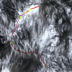
Image 1: The
Gasherbrum area, seen from space.
|
Image 1:
BC
(basecamp) - 5 150 m
C1 - 5 950 m
C2 - 6 300 m
C3 - >7 000 m
C4 - >7 100 - 7 300 m
Hidden
Peak: 8 068 m.ö.h
First attempt for to reach the top: apx. Juli
20:th
|
Using this technique we have produced a
number of images. They are available in our
"3D-Gallery"
|